B.C. serial killer Robert Pickton dead following prison attack
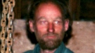
Convicted B.C. serial killer Robert Pickton, who preyed on women he lured from Vancouver's Downtown Eastside to his rural pig farm, has died.


The remnants of Hilary, the first tropical storm to hit Southern California in 84 years, are making their way further north and are expected to affect Canada's western region this week.
"It's going to move its way northward and drive significant rain in southern Alberta and parts of Saskatchewan, and even into central Manitoba," CTV Your Morning's chief meteorologist Kelsey McEwen said Monday.
According to Environment Canada's weather tracker, showers are likely throughout Monday for southern Alberta stretching as far up north as Red Deer.
The central part of Saskatchewan is expected to see some rain until Thursday, with a risk of thunderstorms on Tuesday morning averaging a rainfall amount between five and 10 millimetres.
The southeastern parts of B.C. should also expect some showers between Monday and Wednesday.
Kamloops and West Kelowna, which are among the many areas in B.C. dealing with active wildfires, are expected to get some light rain starting tonight. Slightly northern areas like Quesnel and Williams Lake are at risk of thunderstorms starting on Tuesday afternoon.
McEwen said the storm's impacts will be felt into Tuesday evening in some of the affected areas.
Hilary first made landfall on Sunday in the arid Baja California peninsula on Sunday, where one person drowned. Then, it drenched some areas of the southern U.S. like Palm Springs as it dropped more than half an average year's worth of rain by Sunday evening.
The National Hurricane Centre in Miami downgraded Hilary to a post-tropical cyclone in its Monday advisory, but still warned ongoing "life-threatening" flooding should be expected in parts of the U.S. until Tuesday.
"I think the biggest impact from the remnants of that system is going to be the rainfall," Justin Shelley, a meteorologist with Environment and Climate Change Canada, told CTVNews.ca in an interview Monday.
"It's long past its prime as a hurricane. It's lost all of its tropical features that hurricanes have. So really, it's just a bit of moisture that's left over from that hurricane that's going to be injected north up towards Western Canada."
However, he added that most of that moisture would fall further east of areas such as Kamloops and Kelowna.
That said, rainfall amounts could reach upward of 50 or 60 mm in a 48-hour period.
"We'd certainly like to see sort of a longer lasting, longer duration system to really help provide a bit more moisture to these areas that need it the most. But this time, it looks like it's going to be a relatively short-lived event, maybe two to three days at most. But I'm sure every little bit of precipitation helps in this case," Shelley said.
Once that system moves out, he said this could lead to the further spread of wildfire smoke into parts of Western Canada later in the week, although this would depend on a number of factors such as the size of the fires and wind direction.
"So just be on the lookout for that," Shelley said.
The rainfall advisories in Canada come at a time when the air quality is plummeting due to extensive wildfires in the western region.
As of Monday afternoon, the government of Canada had active weather alert statements for communities in southern B.C., southwest and northern Alberta, northern Saskatchewan and the Northwest Territories as wildfire smoke continued to cause poor air quality and reduce visibility.
"People with lung disease (such as asthma) or heart disease, older adults, children, pregnant people and people who work outdoors are at higher risk of experiencing health effects caused by wildfire smoke," read one of the special weather statements.
As of 3:20 p.m. ET, Canada's air quality ranked third worst worldwide on the World Air Quality Index project, a non-profit data-driven map monitoring air pollution in 130 countries, based in Beijing, China.
Convicted B.C. serial killer Robert Pickton, who preyed on women he lured from Vancouver's Downtown Eastside to his rural pig farm, has died.
Two young children and three adults were seriously injured in a major collision on Highway 417 between Palladium Drive and Carp Road in Ottawa's west end Friday afternoon.
The Department of National Defence is moving approximately 1,000 employees out of an office building in Ottawa's Lowertown neighbourhood, citing safety concerns for its employees.
A newborn is dead after being delivered via emergency C-section to a woman in police custody.
Jennifer Lopez has cancelled her 2024 North American tour, representatives for Live Nation confirmed to The Associated Press.
After years of price increases and a decline in customers, fast food chains in the United States are competing with each other and offering value deals in hopes of bringing more foot traffic into their establishments.
There's a luxury 'tree home' for sale in Calgary.
Marian Shields Robinson, the mother of Michelle Obama who moved with the first family to the White House when son-in-law Barack Obama was elected president, has died. She was 86.
The federal Liberal government learned Friday it might have to retreat on a proposal within its electoral reform legislation to delay the next vote by one week, after all opposition parties came out to say they can't support it.
Convicted B.C. serial killer Robert Pickton, who preyed on women he lured from Vancouver's Downtown Eastside to his rural pig farm, has died.

Saskatchewan teachers and the province are set to resume negotiations on Wednesday.
Premier Danielle Smith is questioning some last-minute amendments to the Liberal government's Bill C-59 that she says muzzles the energy industry, which she sees as the chief driver of environmental innovation in Canada.
While mild – and in some cases damp – weather may be persisting in parts of B.C., the next extreme heat event could arrive as early as next week, according to a warning preparedness meteorologist with Environment and Climate Change Canada.
Halifax pedestrians got an unexpected sight Thursday night when they spotted a deer in the downtown area.
Two young children and three adults were seriously injured in a major collision on Highway 417 between Palladium Drive and Carp Road in Ottawa's west end Friday afternoon.

Marian Shields Robinson, the mother of Michelle Obama who moved with the first family to the White House when son-in-law Barack Obama was elected president, has died. She was 86.

Democratic Sen. Joe Manchin of West Virginia announced Friday he has switched his registration to independent, raising questions about his political plans since the move could help his chances should he seek elected office again in a state that has turned heavily Republican.
The ambush shooting death of a Minneapolis police officer has stunned a department that has struggled to fill its ranks since the murder of George Floyd and the ensuing turmoil.
U.S. President Joe Biden on Friday detailed a three-phase deal proposed by Israel to Hamas militants that he says would lead to the release of the remaining hostages in Gaza and could end the grinding, nearly eight-month-old Mideast war.
A climber from Malaysia who was stranded for three days near the top of North America's tallest mountain following a summit push was rescued Friday, but his partner was dead, officials said. A third member of their team had been rescued this week after descending lower on Denali in Alaska.
The hush money case that culminated in a conviction of Donald Trump this week was the first of four criminal prosecutions brought against the former president -- and likely the only one to reach trial before the November elections. Here's a look at where the other cases stand.

The federal Liberal government learned Friday it might have to retreat on a proposal within its electoral reform legislation to delay the next vote by one week, after all opposition parties came out to say they can't support it.
The Canadian government remained quiet Friday after a New York court convicted Donald Trump as a felon, despite the Liberals repeatedly trying to draw equivalencies between the former U.S. president and the Canadian Conservative leader.
Months before British Columbia sought to scale back its drug decriminalization pilot project, the federal government's own polling suggested to officials that a majority of Canadians believed the policy would lead to an increase in overdoses.

Health Canada recalled various items this week, including more unauthorized products, counterfeit drugs and bassinets.
A genetically engineered pig kidney has been removed from a transplant patient after it started losing function, according to a statement on Friday from NYU Langone Health. The patient, 54-year-old Lisa Pisano of New Jersey is stable and has started dialysis, her doctors said.
Women who closely followed a Mediterranean diet lived much longer than those who did not, according to a new study that followed more than 25,000 women for 25 years.

Google said Friday it has made "more than a dozen technical improvements" to its artificial intelligence systems after its retooled search engine was found spitting out erroneous information.
U.S. federal regulators have given Amazon key permission that will allow it to expand its drone delivery program, the company announced Thursday.
The company behind a popular independent television station in Newfoundland and Labrador says it was hit by a cyberattack.

Eminem appears to be killing off his alter ego in his latest project, an album titled, 'The Death of Slim Shady (Coup de Grace).'
Jennifer Lopez has cancelled her 2024 North American tour, representatives for Live Nation confirmed to The Associated Press.
A local business in the community of Embrun, southeast of Ottawa, got quite the surprise when a social media sensation placed an order with their online business, Ability Hive.

Loblaw is testing smaller-format discount stores across the country this year as shoppers increasingly look for ways to save on their grocery bill.
Indigo Books & Music Inc. says Trilogy Investments LP has acquired all of the retailer's outstanding shares.
Unifor has filed an unfair labour practice complaint against Amazon amid a vote by workers at a Delta, B.C., warehouse over whether they want to join the union.

There's a luxury 'tree home' for sale in Calgary.
The Romance Writers of America has filed for bankruptcy protection following several years of infighting and allegations of racism that fractured the organization, causing many of its members to flee.
You'll have a lot more energy throughout the day if you get a good night's sleep, but not everyone does due to a medical condition.

Canada's Leylah Fernandez is out of the French Open after losing 6-4, 7-6 (5) to Ons Jabeur of Tunisia in the third round Friday.
Mike Tyson's fight with Jake Paul has been postponed after the 57-year-old Tyson fell ill on a flight last weekend.
The Florida Panthers are a victory away from securing a berth in the Stanley Cup final and the Edmonton Oilers are looking for a road win in a pivotal Game 5 at Dallas.

The U.S. Department of Labor on Thursday sued South Korean auto giant Hyundai Motor Co., an auto parts plant and a labour recruiter over illegal use of child labour in Alabama.
Richard D'Agostino says he was aghast to find out that it was going to take him over an hour to get to Dollard-des-Ormeaux from downtown Montreal.
A new study finds fewer Canadians say they're interested in buying an electric vehicle as concerns remain about limited driving ranges, high prices and a lack of charging stations.

A hefty donation by a renowned local activist to the University of Winnipeg has created what is believed to be the most comprehensive two-spirit archives in all of Canada.
Leanne Van Bergen discovered a skulk of 10 baby foxes, and two mothers, had made themselves at home on her property in Beausejour.
An 81-year-old Waterloo, Ont. woman thought she’d never ride a horse again after a brain bleed led to severe physical complications.
A CP24 camera caught the moment a driver frantically got out of her car as it was being dragged by a truck on Avenue Road Wednesday afternoon.
Prince Edward Island is celebrating its first-ever International Day of Potato on Thursday.
The president of Covered Bridge Chips in New Brunswick is hoping to have his factory rebuilt for late 2025 following a devastating fire last year.
Students and staff at Winnipeg’s Westwood Collegiate had a unique problem to solve this month; how do you lead ducks to water from the school’s courtyard when 12 of them can’t fly yet?
Debby Lorinczy remembers her father as an amazing person and as a man who also made an amazing discovery.
Abigail Strate is a member of the Canadian national ski jumping team and an Olympic bronze medallist. She's also a certified beekeeper.
Convicted B.C. serial killer Robert Pickton, who preyed on women he lured from Vancouver's Downtown Eastside to his rural pig farm, has died.
Vancouver police say they arrested 14 people for blocking traffic and railroad tracks in East Vancouver Friday.
Police say they have identified two men responsible for a "sophisticated" break-in at a jewelry store in Surrey, B.C., including one man who remains at large and is now wanted on a Canada-wide warrant.

Newly released documents suggest Ontario’s so-called ‘Crypto King’ paid for months of world travels with $13,000 worth of Scene+ points while bankrupt – but how?
Convicted B.C. serial killer Robert Pickton, who preyed on women he lured from Vancouver's Downtown Eastside to his rural pig farm, has died.
The Bank of Canada’s next interest rate announcement is just around the corner and Toronto residents with mortgage renewals will be keeping a close eye.

One person is clinging to life and police are investigating following reports of a shooting in north Calgary.
Convicted B.C. serial killer Robert Pickton, who preyed on women he lured from Vancouver's Downtown Eastside to his rural pig farm, has died.
Calgary police have charged a man in two seemingly random attacks at local malls on Thursday that resulted in two people being injured.

Two young children and three adults were seriously injured in a major collision on Highway 417 between Palladium Drive and Carp Road in Ottawa's west end Friday afternoon.
The Department of National Defence is moving approximately 1,000 employees out of an office building in Ottawa's Lowertown neighbourhood, citing safety concerns for its employees.
A local business in the community of Embrun, southeast of Ottawa, got quite the surprise when a social media sensation placed an order with their online business, Ability Hive.

Bloc Québécois and Conservative MPs are outraged by Liberal MP Angelo Iacono's suggestion that Quebec would benefit from becoming an officially bilingual province, rather than having only French as its official language.
Police and intervention workers were making house calls in Lachine's Duff Court neighbourhood Friday, two days after a young father was killed on a basketball court in front of families.
The Jarjour family can finally start mourning, two months after Faraj Jarjour died in Cuba. The 68-year-old man's body has finally returned to Montreal by way of Russia after he died on vacation in Cuba.

A newborn is dead after being delivered via emergency C-section to a woman in police custody.
While there's more pressure on the players now that they, as a group, have come further than before, Oilers head coach Kris Knoblauch said that his and the players' jobs are about "creating some confidence and assuring that things are going to be OK."
The urban-planning concept of 15-minute cities was the main topic of conversation at Edmonton city hall this week.

A 21-year-old man is facing several assault charges after he allegedly hit three people with a stolen vehicle in Beaver Bank, N.S., early Thursday morning.
Nova Scotia Health is asking for the public's help in locating a patient missing from a Halifax hospital.
Students from Astral Drive Junior High in Cole Harbour, N.S., from Grade 8 and 9 organized a walkout Friday morning, protesting their concerns with violence on school grounds.

A new exhibit at the Canadian Museum for Human Rights is highlighting how the queer community was targetted by the Canadian government, as Pride Month gets underway in June.
It likely isn’t a surprise for many Manitobans, but it was a wet month of May in the province.
An animated short documentary featuring a 91-year-old Misericordia Place resident premiered on Friday.
Saskatchewan teachers and the province are set to resume negotiations on Wednesday.
SaskPower says two sites near Estevan have been deemed likely spots for nuclear power generation should the province follow through with plans to build a small modular reactor (SMR).
A 41-year-old man is facing three counts of attempted murder after police say he intentionally rear ended another vehicle at a high rate of speed in Moose Jaw Thursday evening and then assaulted someone with a baseball bat.

Habiton Solomon, who was wanted on a Canada-wide warrant for a fatal 2023 shooting in Kitchener, Ont., is now in police custody.
Canada is getting not one – but two – celestial shows over the next few days. Keep an eye on the sky for the northern lights and parade of planets!
A Mennonite father who killed his one-year-old son with an axe may be allowed to travel to parts of southern Ontario in the coming months
Saskatchewan teachers and the province are set to resume negotiations on Wednesday.
A brief break during Wednesday's city council meeting nearly cost the city dearly.
Saskatoon police have announced an extension to their ongoing landfill search for answers in the Mackenzie Trottier case.

A man wanted for first-degree murder in Alberta was arrested this week after police deployed a spike belt on Highway 17 near Schreiber, Ont.
Convicted B.C. serial killer Robert Pickton, who preyed on women he lured from Vancouver's Downtown Eastside to his rural pig farm, has died.
Sudbury police continue to ask the public for help finding a woman missing since earlier this month as a massive ground search gets underway Friday.

A London man is facing sexual interference charges after allegedly touching a school-aged girl on multiple occasions at a school in the city’s north end.
Inside the Molecular Imaging and Theranostics Department at St. Joseph’s Health Care in London, Ont. (formerly Nuclear Medicine), a patient is prepped for imaging.
It wasn't that long ago that schools were being closed across rural Ontario due to declining enrollment. But on Friday, money flowed to build and expand schools across midwestern Ontario.

Cassie Korzenko, the Barrie woman who pleaded guilty to three counts of impaired driving causing bodily harm for crashing into three pedestrians, arrived at the courthouse three hours late for her sentencing hearing.
Three people were airlifted to a trauma centre after a collision in the Township of Minden Hills involving five motorcycles and a pickup truck.
A man from Bradford accused of breaking into the home of a 15-year-old is facing child luring and sexual assault charges.

Lisa Williams retired Friday after 38 years as the female voice of ‘The Morning Drive’ on AM800 News. Over the years, Williams has done just about every job in the station including producing radio shows, hosting call-in specials, weekend DJ shifts and remote reports.
There are a lot of volunteers from Essex County in Detroit this weekend for the Grand Prix. The race is back in the heart of Detroit for a second straight year, and race car driver Jordan Taylor likes the changes to the track.
One beach in Windsor-Essex is not recommended for swimming due to high bacteria levels. Sandpoint Beach has been listed with an E. coli level of 347 — all of the area beaches are between 15 and 108.
Convicted B.C. serial killer Robert Pickton, who preyed on women he lured from Vancouver's Downtown Eastside to his rural pig farm, has died.
The Victoria Fire Department has a new tool in its toolbox. The department says its first fully electric fire truck will do everything the old diesel-powered fire trucks do with some new capabilities.
Meetings are underway between University of Victoria officials and protesters at the Palestinian solidarity encampment on campus.

Mounties in Kelowna have deemed a fire that ripped through an automotive repair business in Kelowna over the weekend suspicious in nature.
Mounties in Kamloops are appealing for information after two recent reports of a man chasing children in a park.
Firefighters in Kelowna were busy on Sunday morning, knocking down two “major” structure fires.

After years of delay, twinning of Highway 3 between Taber and Burdett is underway.
People who live around the police range can expect to hear plenty of shots fired Friday evening but don’t sweat it – it’s just a test.
In the early hours of Monday morning, a grizzly bear and her two cubs broke into a sheep pen on a farm at the Spring Point Hutterite Colony near Brocket, Alta.

Six people are facing drug and several other charges after police in Sault Ste. Marie raided a residence on Wellington Street West on Thursday evening.
A man wanted for first-degree murder in Alberta was arrested this week after police deployed a spike belt on Highway 17 near Schreiber, Ont.
A Sault Ste. Marie man, 29, is charged with assault and mischief after disruptive incidents at two businesses just hours apart.

Health officials in Newfoundland and Labrador say they are only weeks away from a solution to move unclaimed human remains out of roadside freezers and into a nearby hospital.
The company behind a popular independent television station in Newfoundland and Labrador says it was hit by a cyberattack.
A skull was found along a backroad near St. John's more than 20 years ago. Now, police have finally identified the victim of the homicide.
The Shopping Trends team is independent of the journalists at CTV News. We may earn a commission when you use our links to shop. Read about us.


