
Bathroom break nearly derails $22 million project at city council meeting
A brief break during Wednesday's city council meeting in Saskatoon nearly cost the city dearly.


Canadians can get ready for the gift of snow as some areas may see up to 40 centimetres this week.
Environment Canada issued a winter storm watch for some parts of Ontario and Quebec, suggesting as much as 40 centimetres of snow may blanket some areas of the provinces starting Tuesday.
In Ontario, areas like Elliot Lake, Greater Sudbury, and Prescott and Russell will experience heavy snowfall and blowing wind, with the worst conditions expected on Tuesday night and dipping into Wednesday morning, the environment agency said.
Affected areas of Ontario could see 15 to 30 centimetres of snowfall, and northeast winds gusts of up to 60 km/h, resulting in poor visibility at times.
In Quebec, areas including Gatineau could see 10 to 20 centimetres of snow, which may change to ice pellets or freezing rain Tuesday night.
Environment Canada said a major storm will enter western Quebec on Tuesday afternoon and reach central Quebec on Tuesday evening.
Heavy snowfall between 20 and 40 centimetres could blanket the Chibougamau area, and the weather agency warned of strong winds and blowing snow.
Environment Canada issued extreme cold warnings for parts of Yukon, Northwest Territories and Saskatchewan, with some temperatures expected to feel like a staggering -50 thanks to the wind chill.
A cold "episode" is expected in parts of N.W.T., with frigid wind chills of -50 till mid-week.
An arctic airmass is expected to "settle" over the Old Crow, Yukon, area, bringing "bitterly cold wind chills," and temperatures sitting at the -35 C mark, with combined wind gusts up to 20 km/h, an Environment Canada warning read.
The cold air could also stretch to areas like Saskatchewan's Cree Lake and Key Lake. Extreme cold warnings predict it may feel as cold as -45, with severe cold wind chill throughout the week.
Parts of B.C. could see between 10 to 20 centimetres of snow Tuesday evening through Wednesday morning, with higher snowfall amounts over higher terrain.
According to Environment Canada, visibility may suddenly be reduced in heavy snow.
In Newfoundland and Labrador, a blizzard warning was issued for the Cartwright and Black Tickle areas. Wind gusts are expected to reach speeds of 80 to 90 km/h, with visibility near zero in blowing snow.
The areas could see five to 10 centimetres of snow.
The warning said that areas like St. John's and its vicinity will see heightened water levels, reaching six to eight metres in height, breaking upon approach to shore.
"Water levels exceeding high astronomical tide, with large breaking waves pushing water onto vulnerable sections of the coastline," the warning read.
The highest risk of flooding is expected during high tide on Monday and Tuesday morning. These long-period swells are attributed to an intense storm south of Greenland, where it is expected to remain stationary for several days.
The public is advised to stay clear from the shoreline, Environment Canada said.
A brief break during Wednesday's city council meeting in Saskatoon nearly cost the city dearly.
Research shows that art experiences, whether as a maker or a beholder, transform our biology by rewiring our brains and triggering the release of neurochemicals, hormones and endorphins.
Mackenzie Hughes had the dream scenario of winning the RBC Canadian Open in his hometown within reach but then it all slipped away.
A motorcycle driver is facing charges after being caught on Highway 417 doing wheelies and weaving in and out of traffic, the Ontario Provincial Police (OPP) says.
The Edmonton Oilers rode their special teams and goaltender to victory on Sunday, beating the Dallas Stars 2-1 to win the National Hockey League's Western Conference and earn a berth in the Stanley Cup final against the Florida Panthers.
The Abbot Pass hut stood for decades in a rugged saddle between two iconic peaks, overlooking the limpid turquoise of Banff National Park's Lake Louise — a destination for alpinists from around the world until the ground melted beneath it and forced its closure.
South Korea said Sunday it’ll soon take retaliatory steps against North Korea over its launch of trash-carrying balloons across the border and other provocations.
People around the world are observing National Cancer Survivor Day, an annual celebration held to honour patients who have been through the often difficult and traumatic experience of living with cancer.
Emergency response crews are on the scene Sunday morning after a vehicle plunged into the Riviere des Prairies in Montreal.

Legislation restricting disruptive protests targeting B.C. schools came into effect Friday, with the province saying there have been 20 such incidents since last September.

One person suffered life threatening injuries following a crash along Stoney Trail Saturday afternoon.
A group of protesters briefly blocked the Winnipeg Pride Parade on Sunday.
People around the world are observing National Cancer Survivor Day, an annual celebration held to honour patients who have been through the often difficult and traumatic experience of living with cancer.
A motorcycle driver is facing charges after being caught on Highway 417 doing wheelies and weaving in and out of traffic, the Ontario Provincial Police (OPP) says.
Emergency response crews are on the scene Sunday morning after a vehicle plunged into the Riviere des Prairies in Montreal.

Donald Trump has joined the popular video-sharing app TikTok, a platform he once tried to ban while in the White House, and posted from a UFC fight two days after he became the first former president and presumptive major party nominee in U.S. history to be found guilty on felony charges.

South African President Cyril Ramaphosa called Sunday for his country's political parties to overcome their differences and find "common ground" to form the first national coalition government in its young democracy.
The iconic yellow and green of Brazil's flag mixed with a sea of rainbow-coloured tutus, hand fans and drag queen hairdos at Sunday's LGBTQ+ pride parade in Sao Paulo, Brazil.
South Korea said Sunday it’ll soon take retaliatory steps against North Korea over its launch of trash-carrying balloons across the border and other provocations.
Mexicans are voting Sunday in historic elections weighing gender, democracy and populism, as they chart the country’s path forward shadowed by cartel violence.
A former New Jersey police officer has been sentenced to a total of 27 years in prison in the shooting death of one man and the wounding of another during a high-speed car chase 5 1/2 years ago in the city of Newark.
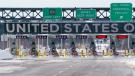
Just as the summer travel season gets into gear, Canadians and visitors could find themselves waiting in long lines at the border — delays that could also deal a blow to the economy.
The Canadian and Chinese defence ministers met in Singapore this week, marking the first in-person meeting between those officials in years.
Canada's ambassador to Russia says while Ottawa has 'grave concerns' about the Kremlin's 'longer-term trends,' the war in Ukraine is 'a primary barrier to a change in the relationship.'

People around the world are observing National Cancer Survivor Day, an annual celebration held to honour patients who have been through the often difficult and traumatic experience of living with cancer.
Research shows that art experiences, whether as a maker or a beholder, transform our biology by rewiring our brains and triggering the release of neurochemicals, hormones and endorphins.
The use of weed to replace alcohol is a growing trend in the United States. In fact, a recent study found — for the first time ever — the daily use of cannabis of any kind among Americans surpassed the daily use of alcohol.

Plant biologist Marcus Samuel has been working for more than a decade to improve the climate resilience of crops.
A Chinese spacecraft landed on the far side of the moon Sunday to collect soil and rock samples that could provide insights into differences between the less-explored region and the better-known near side.
Vancouver was well represented at the Canada-Wide Science Fair in Ottawa this week.

A snowstorm, a Tim Hortons and a group of Canadian artists loosely sums up ‘The Last Timbit,’ a musical hitting the stage in Toronto this month. However, the writers involved explain that it is much more than that. To them, it is a celebration of community, Canadians and togetherness.
Ryan Reynolds this week unveiled arguably the most anticipated and sure-to-be coveted merchandise tied to his upcoming 'Deadpool' sequel: the movie’s novelty popcorn bucket.
Eminem appears to be killing off his alter ego in his latest project, an album titled, 'The Death of Slim Shady (Coup de Grace).'

Saudi Arabia and allied oil producing countries on Sunday extended output cuts through next year, a move aimed at supporting slack prices that haven't risen even amid turmoil in the Middle East and the start of the summer travel season.
The few customers looking for an edible option at a Quebec cannabis store (SQDC) will have noticed some new options on the shelves though the weed-infused poutines sauce, jerky and sausages are not increasing the bottom dollar.
During the pandemic, the Ontario government started to hand out cash to parents to help offset the cost of at-home learning while schools were shuttered.

From Star Wars costumes to mashed potato bars to mid-week soirees, Manitoba couples are finding ways to personalize their weddings in new and creative ways.
The few customers looking for an edible option at a Quebec cannabis store (SQDC) will have noticed some new options on the shelves though the weed-infused poutines sauce, jerky and sausages are not increasing the bottom dollar.
As the Edmonton Oilers battle the Dallas Stars in the Stanley Cup Playoffs' Western Conference Finals, there's some beef brewing off the ice as well.

Scotland's Robert MacIntyre has won the RBC Canadian Open.
The Edmonton Oilers rode their special teams and goaltender to victory on Sunday, beating the Dallas Stars 2-1 to win the National Hockey League's Western Conference and earn a berth in the Stanley Cup final against the Florida Panthers.
Mackenzie Hughes had the dream scenario of winning the RBC Canadian Open in his hometown within reach but then it all slipped away.

Richard D'Agostino says he was aghast to find out that it was going to take him over an hour to get to Dollard-des-Ormeaux from downtown Montreal.
The U.S. Department of Labor on Thursday sued South Korean auto giant Hyundai Motor Co., an auto parts plant and a labour recruiter over illegal use of child labour in Alabama.
A new study finds fewer Canadians say they're interested in buying an electric vehicle as concerns remain about limited driving ranges, high prices and a lack of charging stations.

Car 14 is a luxury passenger car that once made regular runs from London to Port Stanley starting in 1917.
A hefty donation by a renowned local activist to the University of Winnipeg has created what is believed to be the most comprehensive two-spirit archives in all of Canada.
Leanne Van Bergen discovered a skulk of 10 baby foxes, and two mothers, had made themselves at home on her property in Beausejour.
An 81-year-old Waterloo, Ont. woman thought she’d never ride a horse again after a brain bleed led to severe physical complications.
A CP24 camera caught the moment a driver frantically got out of her car as it was being dragged by a truck on Avenue Road Wednesday afternoon.
Prince Edward Island is celebrating its first-ever International Day of Potato on Thursday.
The president of Covered Bridge Chips in New Brunswick is hoping to have his factory rebuilt for late 2025 following a devastating fire last year.
Students and staff at Winnipeg’s Westwood Collegiate had a unique problem to solve this month; how do you lead ducks to water from the school’s courtyard when 12 of them can’t fly yet?
Debby Lorinczy remembers her father as an amazing person and as a man who also made an amazing discovery.

A search effort has been launched for a trio of mountain climbers who were reported overdue after not returning from their excursion near Squamish, B.C.
Nearly three dozen dedicated dogs got their diplomas to become service dogs in B.C. on Sunday.
At Hydra Estiatorio in downtown Vancouver, every dish is prepared or finished with olive oil. The eatery has been hard-hit by shortages and surging prices.

A man has been critically injured and four others are in serious condition following a shooting late Sunday night in north Etobicoke.
A teenage boy has been taken to the hospital with life-threatening injuries following a shooting late Sunday afternoon in Brampton, say paramedics.
A 25-year-old driver is dead after his vehicle crashed into a concrete barrier and rolled over on a Clarington, Ont. highway overnight, the OPP say.

A bear warning is in effect in part of Banff National Park.
The Abbot Pass hut stood for decades in a rugged saddle between two iconic peaks, overlooking the limpid turquoise of Banff National Park's Lake Louise — a destination for alpinists from around the world until the ground melted beneath it and forced its closure.
It has been a banner year for PADS with 33 service teams graduating, five from Calgary.

A two-vehicle collision on River Road that injured three people has once again sparked anger from nearby residents - who say more needs to be done to improve safety on that road.
Residents in Ottawa seized the rare opportunity to walk through the doors of some of the most historical and iconic buildings in the city, as part of the 22nd Open Doors Ottawa event.
The Ottawa Police Service says two people were injured following a serious crash that happened south of Ottawa Sunday afternoon.

Emergency response crews are on the scene Sunday morning after a vehicle plunged into the Riviere des Prairies in Montreal.
There is a 20 per cent increase in tickets handed out to cyclists in Montreal with the most common infractions noted between 2021 and 2023 being wearing headphones, riding an electric bicycle without a helmet and not stopping at red lights.
CTV News Montreal for Sunday, June 2, 2024 with anchor Matt Grillo.

The Edmonton Oilers rode their special teams and goaltender to victory on Sunday, beating the Dallas Stars 2-1 to win the National Hockey League's Western Conference and earn a berth in the Stanley Cup final against the Florida Panthers.
A body was recovered from the North Saskatchewan River early Sunday evening.
A man is dead after he lost control of his motorcycle and crashed into a concrete barrier on Stadium Road early Sunday morning.

As the Weekend of Giving comes to an end, the 40th annual IWK Telethon for Children has come to a close, and this year viewers donated a record-breaking amount, making over $7.5 million.
After a weekend filled with lots of competition and plenty of visitors, the Sail Grand Prix in Halifax has come to a close.
A ceremony honouring New Brunswick peace officers who have died in the line of duty returned as a public memorial on Sunday morning.
A group of protesters briefly blocked the Winnipeg Pride Parade on Sunday.
Pride festivities in Winnipeg will be ending early on Sunday due to severe weather in the city.
The rainy weather that Manitoba saw throughout the month of May looks like it will continue into June.

It was all things aviation at the Regina Flying Club's annual open house over the weekend.
Saskatchewan RCMP are currently responding to a serious collision on Highway 1 west of Swift Current.
What started as a weekly tradition of weekend bargain hunting for old-fashioned antiques has now flourished into a massive treasure trove for Robert Baron and Karen Wilhelm.

Layoffs announced at Home Hardware, a family searching for help to cover the cost of a cancer drug, and a ball python found in a Waterloo park.
Waterloo regional police have arrested a man wanted in connection to a Kitchener shooting.
The curtain may close on Guelph Dance performances if they don’t secure the funding they need to carry on.

Saskatoon’s city solicitor has politely rejected a proposal from the downtown business improvement district to draft a bylaw banning the use of amps by street performers and preachers.
An officer was hospitalized after a speeding driver rammed a police vehicle multiple times, according to the Saskatchewan RCMP.
A brief break during Wednesday's city council meeting in Saskatoon nearly cost the city dearly.

As of Saturday evening, there were still six active wildfires in northeastern Ontario with two new fires confirmed late Friday and one confirmed on June 1 in the region.
During the pandemic, the Ontario government started to hand out cash to parents to help offset the cost of at-home learning while schools were shuttered.
Police have made an arrest in the Kingfisher Lake First Nation following a serious assault in the northwestern Ontario community last week.

In a game that started out slow but picked up in the third period, the Saginaw Spirit are Memorial Cup champions.
Soldiers past and present, even some on horseback, marched through London's Victoria Park to mark the 80th anniversary of D-Day, and ultimately, the end of World War II.
Bruce Power introduced an isotope production line in 2022, producing medical isotopes used in treatments for prostate cancer and neuroendocrine tumours.

Runners of all ages participated in the 12th edition of the Honda Waterfront Half-Marathon in Barrie Sunday morning.
A local athlete from Barrie is celebrating after winning a Division One World Series National Championships in Women's softball.
Orillia OPP have arrested and charged two individuals following a report of a suspicious vehicle in Severn Township.

In Windsor, organizers are hoping to hit the $25,000 mark to help with treatments and an eventual cure.
Willistead Park in Walkerville was busy all day Saturday for the return of the annual Art in the Park festival — and the event, said to be its biggest this year due to the number of vendors in attendance, continues Sunday.
The event is scheduled for July 1 from 10 a.m. to 2 p.m. on University Avenue West between Pelissier Street and Ouelette Avenue

At Hydra Estiatorio in downtown Vancouver, every dish is prepared or finished with olive oil. The eatery has been hard-hit by shortages and surging prices.
A United Airlines plane is being removed from service after several passengers on a flight from Vancouver, B.C., to Houston, TX, felt sick.
A search effort has been launched for a trio of mountain climbers who were reported overdue after not returning from their excursion near Squamish, B.C.

Mounties in Kelowna have deemed a fire that ripped through an automotive repair business in Kelowna over the weekend suspicious in nature.
Mounties in Kamloops are appealing for information after two recent reports of a man chasing children in a park.
Firefighters in Kelowna were busy on Sunday morning, knocking down two “major” structure fires.

The City of Lethbridge has turned the taps back on at four public drinking stations across the city.
Road milling and repaving in Lethbridge is unofficially underway.
The Brooks Bandits added a new title to their list Saturday night when they defeated the Surrey Eagles 4-1 to claim the Rocky Mountain Challenge.

Provincial police in Elliot Lake have arrested a local woman who allegedly threatened to burn down an apartment building in the community.
Two people are facing multiple charges after a pickup truck stolen in Sault Ste. Marie, Ont. was found stuck in the sand at a beach in a Thessalon First Nation community last week.
A Sault man is facing multiple charges – including impaired driving – after an SUV was spotted speeding the wrong way on Highway 17 without its lights on.
Health officials in Newfoundland and Labrador say they are only weeks away from a solution to move unclaimed human remains out of roadside freezers and into a nearby hospital.
The company behind a popular independent television station in Newfoundland and Labrador says it was hit by a cyberattack.
A skull was found along a backroad near St. John's more than 20 years ago. Now, police have finally identified the victim of the homicide.
The Shopping Trends team is independent of the journalists at CTV News. We may earn a commission when you use our links to shop. Read about us.


