

Haiti, Florida, and now Georgia.
Hurricane Matthew has left a trail of devastation in its wake. According to the Associated press, while Haiti's official government death toll stood at nearly 300 as of Friday afternoon, reports say that number is likely significantly higher as on-ground assessments have yet to be completed.
In Florida, over a million people will now have to deal with the aftermath. As the Category 3 storm continues to wreak havoc, here is a closer look at the areas it will impact, the crisis and disaster management resources available in some of these areas and the probable track of some recent tropical storms.
Earlier in the day, the Google Crisis Response team updated their Weather, Hazards, and Emergency Preparedness map to include public alerts, red cross shelters, traffic and weather–related information. The team will continue to add new information to this map as newer content such as satellite images of the affected areas become available.
Impact on people and businesses
The map below uses data from the National Weather Service storm surge warning and watches to show how Hurricane Matthew will impact people and businesses.
According to the National Oceanic and Atmospheric Administration (NOAA), a storm surge warning indicates there is a danger of life-threatening inundation from rising water moving inland from the shoreline somewhere within the specified area, generally within 36 hours. A storm surge watch indicates that life-threatening inundation is possible somewhere within the specified area, generally within 48 hours.
A look at the National Weather Service storm surge warning and watches (Advisory #38)that have been enriched to show the potential impact to people and businesses. (ESRI)
Current and recent tropical storm locations
This map below focuses on current and recent locations of tropical storms, along with forecast positions and probable track of tropical storms.
The live feeds currently cover: the Atlantic and Eastern Pacific, the Central Pacific (Hawaii, etc.), and the Western Pacific and Indian Ocean. The data used to create this map is sourced from the National Hurricane Center, Central Pacific Hurricane Center and Joint Typhoon Warning Center.
A map containing live feed sources for hurricanes and cyclones. (ESRI)
Historical storms
Prior to Hurricane Matthew, data collected by the The Hurricane Research Division (HRD), a part of the Atlantic Oceanographic and Meteorological Laboratory (AOML) in Virginia Key, Florida shows that between 1851-2015, 118 storms have affected Florida. Only 21 storms affected Georgia and 29 affected South Carolina within those same years.
The image below shows the last storms to affect Florida, Georgia and South Carolina before Hurricane Matthew. It was created using the NOAA Historical Hurricane Tracks Tool which allows users to search more than 6,000 tropical cyclones, ranging from 1842 and occurring in over seven major ocean basins around the world.
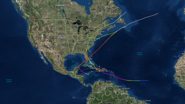
Prior to Hurricane Matthew, the last storm to affect Florida was Hurricane Wilma in 2005. In South Carolina, it was Hurricane Gaston in 2004 and in Georgia it was Hurricane David in 1979. (Source: NOAA Historical Hurricane Tracks Tool)


