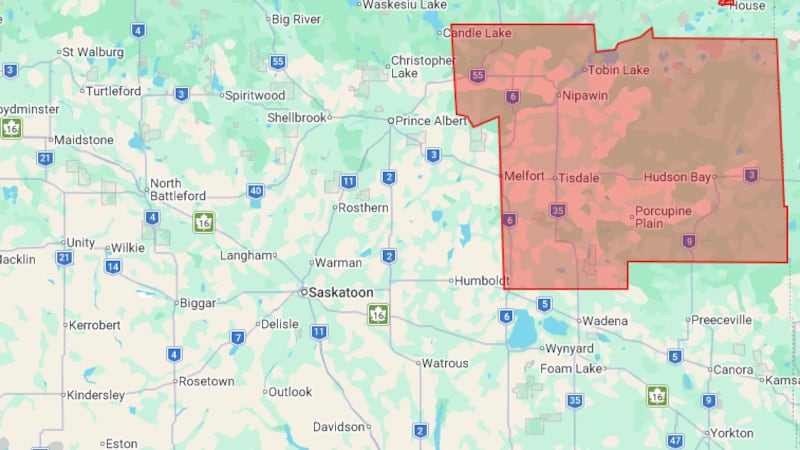
Some parts of Canada have heat and air quality warnings in place Tuesday, while some areas in northern Ontario could see snow. Environment Canada posted heat warnings for Alberta and British Columbia in its online advisory. The government department said it issues heat warnings when it projects that very high temperatures will create an “elevated risk” of heat illnesses, such as heat stroke or heat exhaustion. Environment Canada provided advice to people on its website, such as rescheduling outdoor activities to cooler hours of the day, drinking plenty of water and staying in cooled indoor spaces where possible. Meanwhile, Alberta, Northwest Territories, Nova Scotia and Saskatchewan have air quality warnings. Environment Canada advises people to limit time outdoors, avoid strenuous activities outside and warned that wildfire smoke puts everyone’s health at risk regardless of their age or health conditions. Health risks are greater for seniors, people who live alone, people with diabetes, heart disease, respiratory disease or some other health conditions, people with mental illness and people with limited mobility, according to its notice. Alberta A heat warning has been in effect for much of Alberta since Monday evening. The daytime highs throughout this week are predicted to range between 29 C and 33 C for the Jasper National Park area in the western part of Alberta, for instance, reads Environment Canada’s online notice. But it’s projected to cool down over the weekend. In addition, wildfire smoke has sparked an air quality warning for many places in the province, including Calgary. The conditions are causing “very poor air quality and reduced visibility” and can change hourly, according to Environment Canada. British Columbia Some parts of British Columbia have heat warnings. For instance, Fraser Canyon, northeast of Vancouver, is predicted to have temperatures reaching 35 C along with overnight lows near 18 C over the next three days. Northwest Territories Northwest Territories, including the Yellowknife region, has an air quality warning as a result of wildfire smoke. Ontario Snow is forecast for some parts of northern Ontario this week. “Some areas north of Lake Superior could see rain flip over to snow Wednesday night into Thursday morning,” CTV’s Your Morning meteorologist Kelsey McEwen said in a phone interview with CTVNews.ca on Tuesday. This affects cities north and east of Thunder Bay such as Nipigon, Armstrong, Fort Hope and Marathon, she added. She said the Toronto area, meanwhile, will see a “little bump” in temperatures Tuesday, but it will feel more like fall later in the week with rainy and cool temperatures. Nova Scotia Nova Scotia’s Annapolis County also has an air quality warning. Smoke from the Long Lake wildfire in the region is predicted to “significantly reduce air quality.” Environment Canada said smoke conditions may vary in areas. Saskatchewan Many areas in Saskatchewan, excluding Saskatoon and much of the province’s east, have air quality warnings. Manitoba Manitoba will see a “cooler than average forecast” during the first week of September, with showers Tuesday that could continue overnight and turn into heavier rain on Thursday, McEwen said. Quebec Parts of Quebec will see a similar weather system as Ontario, McEwen said. Montreal, for instance, will be “fairly mild” and “fairly warm” this week until a cold front arrives Thursday night. Salluit, Que., in the north will have cooler single-digit temperatures all week, with a forecast of 3 C and chance of rain showers or flurries Tuesday.