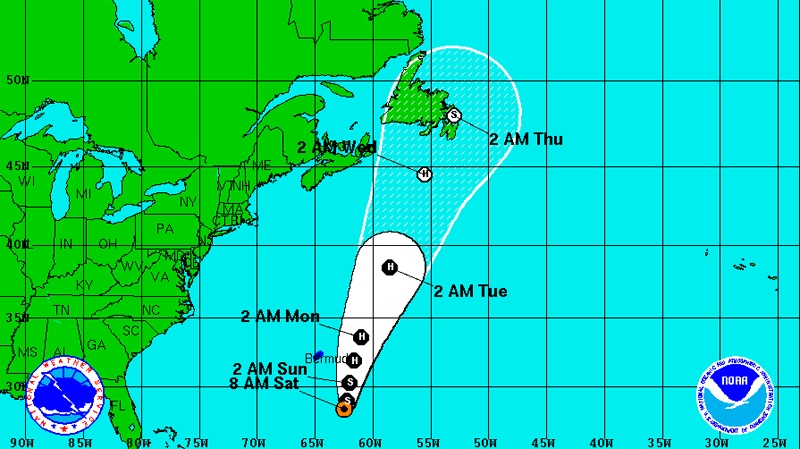
HAMILTON, Bermuda -- Tropical Storm Leslie moved slowly northward Saturday after pausing to spin in place over the Atlantic, and forecasters expected it to strengthen into a hurricane again before passing to the east of Bermuda.
The latest forecasts pointed to the storm going by about 200 miles (320 kilometres) east-southeast of the British territory Sunday afternoon or evening as a Category 1 hurricane, the Bermuda Weather Service said.
"It appears that Bermuda will be spared a direct impact," Wayne Perinchief, the national security minister, said Friday. "However, I urge the public to remain cautious as there is the potential for the storm to re-intensify and change track, and we could experience heavy rain and winds in shower bands."
Some businesses closed early and shops were crowded for a second day with people buying emergency supplies. At least one cruise ship cancelled a stop in Bermuda and the airport was expected to close. Some international flights were cancelled.
Bermuda, a wealthy offshore financial haven and tourist destination, has strong building codes and is accustomed to storms, and many people on the island followed Leslie without fear.
"I have taken precautions," said Gareth Kerr, 29. "The windows have the shutters across and I got supplies such as water and tinned food. If the weather is bad tomorrow I'll just sit indoors."
Still, there was the chance of some flooding, said James Dodgson, a meteorological forecaster for the Bermuda Weather Service. Dodgson said the storm surge was likely to be relatively small at one or two feet but the surge coupled with high tide Sunday could cause some minor flooding in low-lying areas.
The U.S. National Hurricane Center in Miami said that by late Saturday afternoon Leslie had top sustained winds of 65 mph (100 kph), below the hurricane threshold of 74 mph (120 kph).
Leslie was about 240 miles (390 kilometres) southeast of Bermuda and was moving north at 8 mph (13 kph). The U.S. centre said it would likely strengthen into a hurricane by Sunday and was expected to begin gradually increasing its forward speed.
"We expect the weather to go downhill later today with strong gusty winds," said Eric Blake, a hurricane specialist at the U.S. centre.
The total amount of rainfall could reach two inches or more, he said.
Out in the middle of the Atlantic and considered no threat to land, Hurricane Michael was a category 2 storm with maximum sustained winds of 105 mph (165 kph). On Thursday, it was briefly the first Category 3 of the Atlantic hurricane season.
Michael was moving north-northwest at 6 mph (9 kph). It was about 925 miles (1,485 kilometres) west-southwest of the Azores.


