
A petition is currently urging the U.S. government to give Canada the Northwest Angle: a 320-square-kilometre piece of American territory that can only be accessed by land from Manitoba.
Along the world’s longest undefended border, several similar cartographical oddities can also be found. Known as pene-exclaves or practical exclaves, these are parts of a country that that can only be conveniently reached through the territory of another.
POINT ROBERTS, WASH.
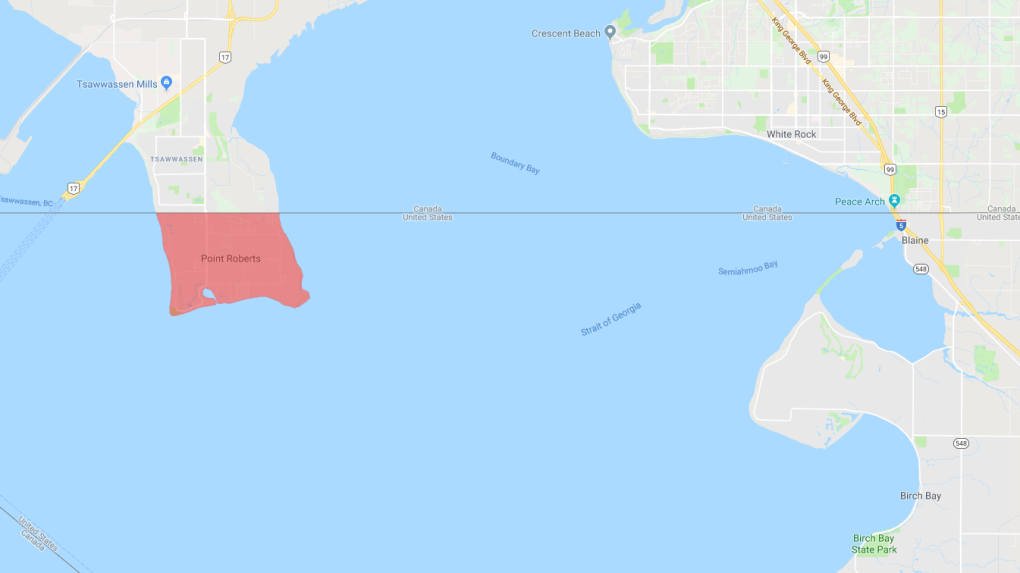
Point Roberts, Wash. can only be accessed by land through Delta, B.C. (Google Maps)
Jutting into the Strait of Georgia on the southern tip of the Tsawwassen Peninsula, Point Roberts in Washington state can only be accessed by land through the city of Delta, B.C. At just over 12 square kilometres, this tiny parcel of American territory was created in 1846 when the Oregon Treaty set the boundary between the western U.S. and British North America at the 49th parallel. Conjoined to mainland Canada yet sitting immediately south of the 49th, Point Roberts was overlooked by British and American negotiators at the time. Today, this American pene-exclave has a population of just over 1,300.
ELM POINT AND BUFFALO BAY POINT, MINN.

Minnesota's Elm Point (right) and Buffalo Bay Point (left) are separated from Manitoba by the 49th parallel. (Google Maps)
In addition to the Northwest Angle, several other parts of the U.S. state of Minnesota can only be reached by land from southeastern Manitoba. Bounded by the waters of Lake of the Woods to the south and mainland Canada to the north, Elm Point and Buffalo Bay Point (which is actually two small pieces of land) are considered American pene-exclaves. Both sit just below the 49th parallel and became a part of the U.S. because of the Treaty of 1818.
AKWESASNE, QUE.

Akwesasne, Que. can only be accessed by land through New York State. (Google Maps)
The Mohawk Nation at Akwesasne straddles New York State and the provinces of Ontario and Quebec. A small part of the Quebec portion of the First Nations’ territory is considered a pene-exclave as it bounded by the waters of the St. Lawrence and St. Regis Rivers to the north and east and the U.S. mainland to the south. To drive to this nearly three-square-kilometre parcel of land from the rest of Canada, you would have to enter upstate New York. This territory’s Canadian status was defined in the 1842 Webster-Ashburton Treaty between the U.K. and U.S. Thanks to the 1794 Jay Treaty, though, members of this Mohawk Nation are able to travel freely between the two countries.
PROVINCE POINT AND PROVINCE ISLAND, VT.

Province Point (left) on Lake Champlain and the southernmost tip of Province Island (right) on Lake Memphremagog are parts of Vermont that can only be reached by land from Quebec. (Google Maps)
Because of the 1842 Webster-Ashburton Treaty, which defined large parts of the border between present-day Quebec and present-day Vermont just north of the 45th parallel, two incredibly tiny and now-uninhabited parcels of land -- Province Point on Lake Champlain and the southernmost tip of Province Island on Lake Memphremagog -- are now part of the U.S.


