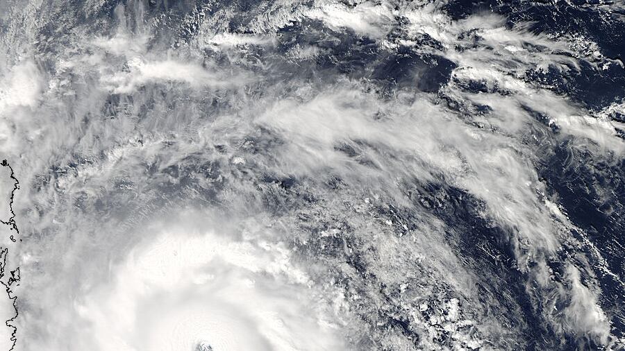
Typhoon Haiyan slammed the Philippines Friday, with estimated maximum sustained winds of 235 kph and gusts up to 275 kph. Late Saturday, officials in the central Philippines said the death toll could reach 10,000.

NASA satellites captured images of Haiyan as it neared the Philippines starting as early as Nov. 4. Here's a look at the typhoon as pictured by NASA satellites.

Nov.4

Data and this image were taken by NASA's TRMM satellite at 10:42 UTC. Data showed rainfall near the centre of the storm to be falling at a rate of between 50 and 60 mm per hour.

Haiyan Nov. 4


Nov. 6

Data and this photo were taken by Nasa' TRMM Satellite at 10:26 UTC. NASA's data revealed that rain was falling at an estimated rate of over 100 mm per hour around Haiyan's eye (seen in purple) and winds were estimated to be over 249 kph. At the time, the typhoon was located just northeast of the island nation of Palau.

Haiyan Nov. 6


Nov. 7

This photo was taken by NASA's Aqua satellite at 4:25 UTC. It shows thick bands of thunderstorms surrounding the eye of the storm.

Haiyan Nov. 7

Data and this infared image were taken by NASA's Aqua satellite at 4:25 UTC. NASA's data revealed cloud top temperatures as cold as -63.15 C in the band of thunderstorms and near the storm's centre.

These cold temperatures (seen in purple) indicated very powerful thunderstorms with the high potential for heavy rain, NASA said.

Haiyan Nov. 7

As of 5:00 UTC, Haiyan's maximum sustained winds were estimated to be near 305 kph, according to NASA.

This short animation of MTSAT satellite data, courtesy of NASA and the University of Wisconsin, shows Haiyan's progression on Nov. 7 from 9:30 UTC to 15:30 UTC as it moved over the Philippines.


Nov. 8

Data and this photo were taken by NASA's TRMM Satellite at 00:19 UTC. NASA's data showed Haiyan had a well-defined eye, which was surrounded by areas moderate rain (seen in this photo in the green ring with the blue centre).

At the time, Haiyan's sustained winds were estimated to have dropped to around 297 kph, according to NASA.

Haiyan Nov. 8

This photo taken by NASA's Aqua satellite at 5:10 UTC, showed that Haiyan kept its general structure as it moved over the eastern region of the Philippines.

Haiyan Nov. 8

This image and data were taken at 10:08 UTC by NASA's TRMM Satellite. The photo shows that Haiyan's centre is less organized, NASA said.

Heavy areas of rain are pictured in red and remain south of centre. At this time, Haiyan's sustained winds were estimated to be around 268 kph.

Haiyan Nov. 8

Continue tracking Haiyan with NASA satellite images by visiting the NASA website.


Google Crisis Map of the typhoon's path: