Satellite images show Fort McMurray damage
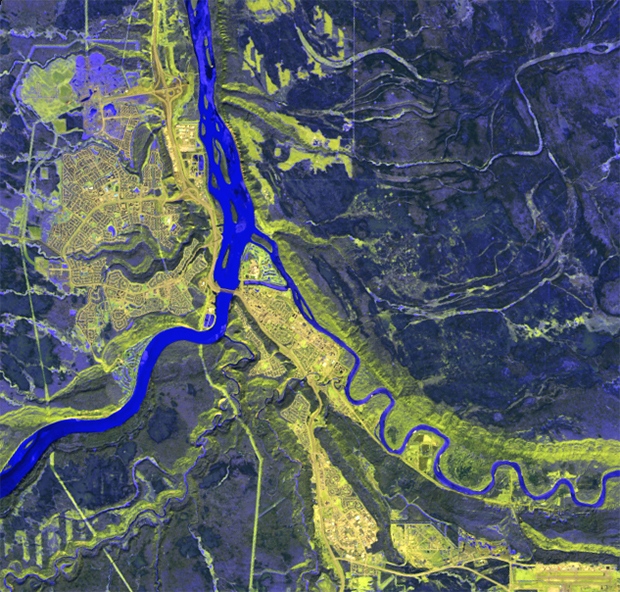
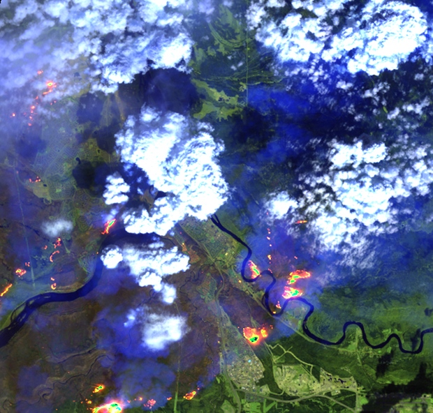
Satellite images provided by Effigis show the Alberta city of Fort McMurray on April 10, 2016, before the wildfires, and May 4, 2016.
Montreal-based Effigis has released two satellite images of Fort McMurray, showing the widespread damage caused by an out-of-control wildfire.
The second image, from May 4, 2016, was taken when the fire was about 850 square kilometres in size.
Latest on Fort McMurray
-
A new study indicates dust from homes in Ford McMurray, Alta., had normal levels of indoor contaminants a year after a devastating forest fire hit the city, suggesting residents did not face an elevated health risk in the aftermath of the blaze.
-
Newly published research suggests the fire cast a lasting shadow over the lives of many residents who are still experiencing elevated rates of depression and related mental-health problems.
-
Walmart Canada has been ordered to pay a $20,000 fine for selling contaminated food after a devastating wildfire in northern Alberta two years ago.
-
It’s been two years since wildfires in Fort McMurray, Alta., destroyed more than 2,500 homes in the area and officials say roughly 80 per cent of those houses are still not fully restored.
-
Alberta tables legislation to clarify responsibilities in natural disasters
-
Man says Fort McMurray wildfire saved his life by forcing weight loss
-
Couple who lost home in Fort McMurray fire wins $1M lottery
-
Mental effects of wildfire lingering in Fort McMurray
-
Prevention, disaster management are key lessons in Fort McMurray fire: report
-
Rebuilding homes in Fort McMurray, Alta., going faster than expected, CMHC says
Latest videos
-
Fort McMurray Fire Chief Darby Allen became a voice of strong leadership during the wildfires. Breanna Karstens-Smith on his retirement.
Air Date: February 24, 2017
Janet Dirks continues CTV's top ten stories of 2016 looking at the devastating impact of the wildfires in Fort McMurray and the recovery.
Air Date: December 30, 2016
-
The first wave of wildfire evacuees returned to Fort McMurray Wednesday as others continue to wait to check the damage. Janet Dirks reports.
Air Date: June 1, 2016
Officials break down the evacuee re-entry schedule for the wildfire impacted areas of Fort McMurray.
Air Date: May 31, 2016
-
Wildfire information officer Travis Fairweather explains how the size of the Fort McMurray wildfire has increased since Monday.
Air Date: May 17, 2016
Omar Sachedina has a look at what could be the next steps for rehabilitating Fort McMurray, including who could get back in first.
Air Date: May 14, 2016
-
For the first time, Prime Minister Trudeau saw the scope of the damage in Fort McMurray first hand. Omar Sachedina reports.
Air Date: May 13, 2016
Fort McMurray evacuee Peter Fortna says he is 99.9 per cent sure his house was destroyed in the wildfires that decimated the region.
Air Date: May 13, 2016
-
Prime Minister Justin Trudeau recounts seeing the destruction in Fort McMurray while speaking to reporters with Alta. Premier Rachel Notley.
Air Date: May 13, 2016
Prime Minister Trudeau announces more people in Alberta, southern Saskatchewan, parts of B.C. will have access to extended EI benefits.
Air Date: May 13, 2016