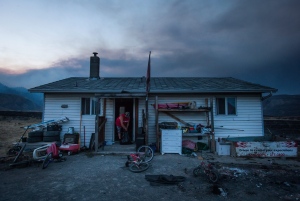
ASHCROFT, B.C. - Wildfires have forced thousands from their homes in British Columbia's central and southern Interior. Here's a list of some fires that the B.C. Wildfire Service says were highly visible or posed a potential threat to public safety as of Monday afternoon:
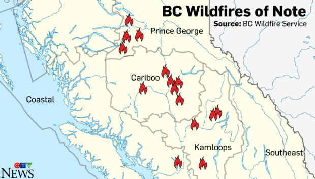
Graphic by Nick Kirmse / CTVNews.ca
Prince George Fire Centre
Tatelkuz Lake: A fire west of Prince George that was out of control and covered an area of 9.5 square kilometres. The fire was caused by lightning and had burned up to the edge of private land.
Big Bend Creek: This fire southwest of Prince George was caused by lightning. It was about 9.6 square kilometres in size and classified as out of control.
Grizzly Lake: Another fire southwest of Prince George. It was 2.5 kilometres in size and was listed as out of control. The fire was caused by lightning.
Sutherland Road: A six-square-kilometre fire, 10 kilometres north of Fort Fraser. It was caused by lightning.
Kamloops Fire Centre
Princeton: An evacuation order was in effect because of this 20-square-kilometre fire north of Princeton. The cause of the blaze was under investigation.
Ashcroft Reserve: A more than 60-square-kilometre fire near Ashcroft. Poor visibility makes it difficult to determine how many structures have been damaged. The cause of the fire was under investigation and an evacuation order was in effect in Cache Creek and areas to the north.
Thuya Lake Road: Evacuation orders and alerts were in effect as a result of this fire, which was four kilometres south of Little Fort. It was just over three square kilometres in size and the cause of the blaze was under investigation.
West of Dunn Lake and North of Dunn Lake: The BC Wildfire Service says it responded to two wildfires near Dunn Lake, about three kilometres northeast of Little Fort, that were expected to run together to form one larger fire on Monday. The combined size of the fires was nine square kilometres, although the fire service says poor visibility makes it difficult to determine the perimeter of the fires. The cause of the fire was under investigation. The fire has prompted an evacuation order.
Cariboo Fire Centre
Gustafsen wildfire: A 50-square-kilometre fire fanned with wind Sunday night was threatening the community of 100 Mile House.
Dragon Mountain: About 25 kilometres southeast of Quesnel, this fire was about 15 square kilometres in size. The cause of the fire was under investigation.
150 Mile House: A 25-square-kilometre fire. Crews have had some success in building containment lines on its west and east flanks. The wildfire service calls it "a dynamic situation," with a focus on protecting Highway 97 and nearby structures.
Hanceville: Numerous fires affecting about 100 square kilometres in the area located about 60 kilometres southwest of Williams Lake. It involved a large area of about 25 kilometres by 40 kilometres. The cause of the fire was under investigation.
Soda Creek: One square kilometre in size, located about 25 kilometres northwest of Williams Lake. The cause of the fire was under investigation.
Spokin Lake Road: A three-square-kilometre fire, about 20 kilometres east of Williams Lake, that has caused an evacuation order.
Wildwood: Crews building containment lines to anchor base of this 20-square-kilometre fire, with efforts on protecting Highway 97 and the community of Wildwood.
Coastal Fire Centre
Harrison Lake East: Nearly two square kilometres in size, this fire is about 30 kilometres north of Harrison Hot Springs. It was 40-per-cent contained.