
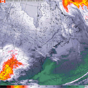
What started off as light snow in parts of Ontario has quickly intensified to a powerful snowstorm that is making its way further down Eastern Canada.
Environment Canada has issued several weather warnings and statements to regions across southern Ontario as a snowstorm strengthens throughout Wednesday evening, expecting to hit some regions with up to 25 centimetres of snow by Thursday morning.
However, as the storm picks up and moves further east, Quebec and provinces in Atlantic Canada are also expected to be hit by the weather system with heavy snowfall and rain.
Get the latest local updates:
POOR VISIBILITY AFFECTING COMMUTE HOME
Jeoff Coulson, meteorologist with Environment Canada, says Ontarians need to take extra precaution on their way home tonight as certain regions will be hit with poor visibility, specifically southern regions closer by the lake.
"We've got an east wind blowing in from the lake that's adding moisture to the storm in areas like Mississauga, Oakville, Burlington and the Hamilton area, so those areas are seeing some poorer visibility than other areas of the province right now," Coulson told CTVNews.ca in a phone interview on Wednesday.
All southern regions in Ontario have a snowfall warning from Environment Canada as most regions, like London, Kitchener and the Greater Toronto Area, can expect 15-20 cm of snow overnight or by Thursday morning when the storm is expected to subside. However, harder hit regions like Prince Edward County, Trenton, Kingston and other areas along the St. Lawrence River could even see 20-25 cm of snow by Thursday morning, Coulson said.
Quebec is also expected to have a difficult commute Wednesday evening and Thursday morning, as the storm makes its way across the Southeast regions of the province bording Ontario and the U.S.. Montreal, Laval and the Gatineau region have a snowfall warning of 15-25 cm for the evening, Environment Canada warned as the regions are expected to be hit with "quickly changing and deteriorating travel conditions."
Quebec City, and areas surrounding it like Saint-Lambert and Portneuf were given a winter storm warning, alerting of wind gusts of 60km/hr as heavy snow and strong winds may reduce visibility to nearly zero in some areas.
"Slow things down, leave lots of space between yourself and the vehicle in front of you and certainly even pedestrians need to take extra caution when walking around in areas where there's been recent snowfall because of the fact that there could be slippery conditions on the sidewalks as well," Coulson said.
ATLANTIC PROVINCES HIT WITH HEAVY RAINFALL
While parts of Atlantic Canada have also been hit with snowfall warnings, rain and wind are also a top concern for Nova Scotia, Newfoundland and the southern regions of New Brunswick.
Rainfall warnings were made for Fredericton and Saint John, N.B. as Environment Canada says the regions can expect 30 to 50 mm of rain as the snow will change to heavy rain and warned the downpour can cause flash floods and water pooling on some roads.
The Moncton region is also expected to be hit with 10 to 15 cm of snow and 15 to 20 mm of rain as the snow changes to rain overnight and become scattered showers Thursday evening.
All of Nova Scotia has a rainfall and wind warning, while Newfoundland will see a mix of rain, snow and wind that will likely pick up by Thursday and won't subside until the end of the week, Coulson said.
"We'll finally see the end of this system totally for most Canadian areas, at this point, by midday to late in the day Friday when the system finally pulls out of Northern Newfoundland," he said.
Environment Canada warned of "significant rainfall" for most of Nova Scotia as they anticipated the province to be hit with 25 to 50 mm of rain. The rain will start in the southwest region early Thursday morning, but there may also be a brief period of snow in the northern areas before it changes into heavy rain.
St. John’s, Grand Falls-Windsor and Gander in Newfoundland are among the regions with wind warnings that are expected to reach wind gusts between 100 to 120 km/h, specifically along the coast, throughout Thursday afternoon and Friday morning.
UNCERTAIN IF LINKED TO POLAR VORTEX, COULD BE START TO COLDER FEBRUARY
For many parts of Canada, it's not uncommon to experience heavy snowfall during January and February. However, due to the milder weather in some parts of the country at the start of the year, Coulson says this weather system may come as a wake-up call to what`s ahead.
"This is a real shift in the weather pattern in many parts of the country because in many places in Canada, for much of January it's not as cold as normal, that includes B.C. and the prairies and the far North, as well as Ontario, Quebec and Eastern Canada," he said.
Meteorologists says a polar vortex that brought Mars-like, frigid temperatures in Siberia earlier this month could potentially hit Canada next in February. However, Coulson says it's not clear whether this current weather system is linked to the polar vortex or it could also be linked to an occasional blast of arctic air.
Nonetheless, this storm is showing patterns of a colder start to February for much of Canada, with some regions potentially experiencing colder temperatures than usual.
"A real shift in that pattern is getting back to not only seasonally cold temperatures for this time of year, but it looks like below normal temperatures for a good part of the country as we go into February," he said.


