Imagery from National Oceanic and Atmospheric Administration (NOAA) satellites shows wildfire smoke drifting over from Nova Scotia to northeastern parts of the U.S.
In the post shared on Twitter, NOAA says that the smoke will continue to bring hazy skies to most parts of the northeast again today.
The smoke is leading to air quality alerts in parts of the U.S., with local weather reports warning that the hazy skies will be most visible approaching the time of sunset on Wednesday.
Outdoor air pollution is a major environmental health problem, according to the World Health Organization (WHO) and can lead to premature death.
Canada’s health guidelines for protection against wildfire smoke include limiting outdoor activity and strenuous physical activity, and drinking plenty of water to help the body cope with the smoke.
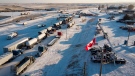
The current wildfires in Nova Scotia have reportedly covered 837 hectares as of today.
There have been 195 wildfires in N.S. this year, burning about 12,817 hectares to date, according to a press release from the Government of Nova Scotia. Last year, there were 152 wildfires in N.S., which burned approximately 3,390 hectares.