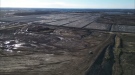
A photo taken by NASA shows what the Quebec wildfires look like from up above.
The image captures the scale of the fires on June 3, where smoke can be seen billowing over western and eastern Quebec and even drifting over into northern Ontario.
The visual was taken from NASA’s Aqua satellite using the Moderate Resolution Imaging Spectroradiometer (MODIS), an instrument which orbits the earth, viewing its entire surface every one to two days and collecting important global data such as the processes and dynamics taking place on the land, in the oceans, and in the lower atmosphere.
As of Monday, there are reportedly 164 wildfires burning across the province, 114 of which are out of control, according to the Quebec government.
About 5,000 people were ordered to evacuate their homes near the city of Sept-Iles in eastern Quebec, soon after the fires erupted. Since then, 9,000 more residents in the nearby areas in western Quebec’s Val-d’Or and Normétal municipalities have been ordered to evacuate.
By Sunday, 138 Canadian Armed Forces soldiers trained to support Quebec’s wilderness firefighters arrived to help, and 100 more are expected to show up Monday, the province said.
Due to the wildfire smoke, the air quality index in southern Quebec and eastern Ontario has been classified as unhealthy, according to Environment Canada’s Air Quality Health Index. The smoke has also taken its toll on their air quality in the U.S. Midwest.
Local officials have discouraged people from going outdoors in Quebec and smog warnings have been put in place in Quebec, including in the city of Montreal.