Winter is striking Canada with a vengeance, with freezing temperatures and delayed flights in B.C., a potential polar vortex brewing in Alberta, and Ontario and southern Quebec bracing for what is expected to be a significant storm this weekend.
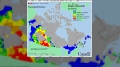
Environment Canada has posted extreme cold warnings for the bulk of Western Canada, with the affected area stretching from southern Manitoba up across Alberta and B.C. into Yukon.
The largest cities in Alberta, Manitoba and Saskatchewan were all dealing with temperatures lower than -20 Celsius on Monday. In Calgary, where the high on Monday was expected to be -28 C, Environment Canada stated that frostbite would develop in minutes, and that it felt like -40 C with the wind chill.
In Regina, the wind chill made it feel like -43 C, the weather agency said.
Warming centres have been activated in Vancouver and five temporary shelters have been opened up in an attempt to protect those stranded outside without a home to turn to. However, advocates say there is still limited space in shelters, with one outreach worker telling CTV News Vancouver that they’ve had to turn away an average of six people per night.
The weather is also impacting travellers. In Vancouver, some would-be-fliers were stuck on the tarmac for 12 hours overnight as snowfall prevented flights from taking off at the Vancouver airport.
The severe cold in Calgary has caused cars to stall and nine different water mains to burst. It’s harder for emergency services to work under these conditions, according to officials, as crews need to warm up in order to go out into the elements and address the issues.
As Western Canada battles the cold, Ontario and Quebec are bracing for storms to hit.
Just before the weekend, a large storm is projected to hit the region. Environment Canada described it as an “intense” low-pressure system, expected to hit southern Quebec late Thursday.
It’s possible that there could be storm surges in parts of Quebec City late Friday as well, the agency reported, and snow squalls throughout southern Quebec are expected over the weekend.
"Plan ahead for your holiday travel plans. Road conditions will be difficult and power outages are possible," Environment Canada stated.
The Greater Toronto Area is projected to start receiving rain or snow late Thursday.
“Temperatures are expected to plummet on Friday leading to a potential flash freeze for locations that receive rainfall,” Environment Canada said in a special weather statement.
There may be blizzard conditions, including strong winds and snowfall, in the area downwind of Lake Huron and Georgian Bay as well, although Environment Canada cautions it is uncertain of specifics for this weekend’s upcoming storm in terms of temperatures and how the storm is expected to move across the region.