Delays and cancellations piled up Wednesday as a mammoth storm system continued to batter parts of Ontario, Quebec and Atlantic Canada.
All public schools in New Brunswick, Nova Scotia and Prince Edward Island were closed Wednesday due to the storm. Schools were also closed in Ottawa – which reportedly saw its first board-wide closure since 1998 – as well as cities including Montreal and Hamilton.
Government offices were closed in many cities in the storm’s path, and people across parts of five provinces were being urged to stay at home if it was not necessary for them to travel. Flight cancellations dotted arrival and departure screens at airports across Eastern Canada.
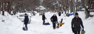
Environment Canada was reporting, as of 11 a.m., that between 30 and 40 cm of snow had fallen in Montreal since Tuesday afternoon. Ottawa had seen 29 cm of snow as of 9 a.m.
Although more snow was still expected to fall on both of those cities into the afternoon, the worst of the storm had moved to the east. Snow was starting to change over to freezing rain and mixed precipitation in southern parts of Nova Scotia and New Brunswick by noon.
All winter storm warnings for Ontario had ended by Wednesday afternoon. Montreal was also no longer under any warnings, although warnings remained for other parts of Quebec – including Quebec City, where the Carnaval de Quebec had cancelled its events for the day.
In the Maritimes, Environment Canada was forecasting 20 to 40 cm of snowfall for New Brunswick by the end of the day, with snow and ice pellet accumulation combining to reach 20 to 30 cm in P.E.I. Nova Scotia was expected to see 15 to 25 cm of snow and ice accumulation before the precipitation tapered off Wednesday night.
- Get local storm coverage from CTV Vancouver, CTV Toronto, CTV Ottawa, CTV Montreal and CTV Atlantic
The storm was being accompanied by high winds, which were expected to cause periods of blowing snow and low visibility. Environment Canada was recommending that people in areas covered by the winter storm warnings avoid travelling unless absolutely necessary.
Municipal officials told CTV Ottawa that it could take up to two weeks for plows to reach every street in the nation’s capital.
West of the Greater Toronto Area, where forecasts had expected the storm to have long since passed through, snow squalls off Lake Huron were expected to leave as much as 25 cm more snow on parts of southern Ontario by Wednesday night.
The Weather Network chief meteorologist Chris Scott told CTV News Channel that a separate storm would likely move into Ontario and Quebec Thursday night, although with warmer weather in the forecast, it would not be as severe.
- What’s open where you are? See closure and cancellation lists from CTV Vancouver Island, CTV Vancouver, CTV London, CTV Kitchener, CTV Toronto, CTV Barrie, CTV Ottawa, CTV Montreal and CTV Atlantic
Winter storm warnings for Vancouver, Victoria and other parts of southern B.C. were ended Wednesday morning. At least 20 cm of snow had fallen across most of that area from the second of two back-to-back storms.
Scott said a third storm was on its way to the area and due to arrive late Thursday.
“Right down by sea level we don’t think there will be as much snow, but still – there will be snow,” he said.
Parts of Alberta and Saskatchewan, including Edmonton and Saskatoon, remained under extreme cold warnings with wind chill values in the -40 range expected Wednesday. Neither city has seen temperatures above -18 C since Feb. 1.