
Widow looking for answers after Quebec man dies in Texas Ironman competition
The widow of a Quebec man who died competing in an Ironman competition is looking for answers.


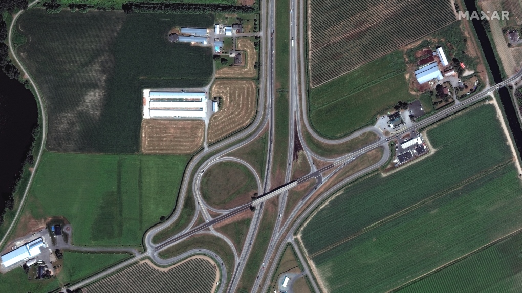
Satellite imagery from before and after the flooding in British Columbia reveal the true devastation the region has experienced.
The images from Nov. 19, provided by the satellite company Maxar Technologies, shows vast areas of green farmland in the Sumas Prairie near Abbotsford, B.C. that are now covered in what appears tobe murky brown water.
Some of the before images also show buildings and highways that are nearly unrecognizable in the second images.
The flooding situation in the Sumas Prairie has improved since these images were captured. On Tuesday, Abbotsford’s evacuation order was downgraded to an evacuation alert as the water levels receded in the area.
The downgrade meant that some residents were allowed to return to their homes. An update from city and provincial officials is expected later Tuesday.
In other parts of B.C., residents are also seeing an improvement. In Merritt, some residents were allowed to return home after the entire community was evacuated last week,
CN railways are expected to resume “limited” service in southern B.C. tomorrow after flooding and mudslides damaged the rail line.
 Images from Nov. 19 show vast areas of green farmland in the Sumas Prairie near Abbotsford, B.C. that are now covered in what appears to murky brown water. (Satellite image ©2021 Maxar Technologies)
(Satellite image ©2021 Maxar Technologies)
 Images from Nov. 19 show vast areas of green farmland in the Sumas Prairie near Abbotsford, B.C. that are now covered in what appears to murky brown water. (Satellite image ©2021 Maxar Technologies)
(Satellite image ©2021 Maxar Technologies)
 Images from Nov. 19 show vast areas of green farmland in the Sumas Prairie near Abbotsford, B.C. that are now covered in what appears to murky brown water. (Satellite image ©2021 Maxar Technologies)
(Satellite image ©2021 Maxar Technologies)
 Images from Nov. 19 show vast areas of green farmland in the Sumas Prairie near Abbotsford, B.C. that are now covered in what appears to murky brown water. (Satellite image ©2021 Maxar Technologies)
(Satellite image ©2021 Maxar Technologies)
 Images from Nov. 19 show vast areas of green farmland in the Sumas Prairie near Abbotsford, B.C. that are now covered in what appears to murky brown water. (Satellite image ©2021 Maxar Technologies)
(Satellite image ©2021 Maxar Technologies)
 Images from Nov. 19 show vast areas of green farmland in the Sumas Prairie near Abbotsford, B.C. that are now covered in what appears to murky brown water. (Satellite image ©2021 Maxar Technologies)
(Satellite image ©2021 Maxar Technologies)
The widow of a Quebec man who died competing in an Ironman competition is looking for answers.
Former NDP leader Tom Mulcair says that what's happening now in a trash-littered federal park in Quebec is a perfect metaphor for how the Trudeau government runs things.
The world is seeing a near breakdown of international law amid flagrant rule-breaking in Gaza and Ukraine, multiplying armed conflicts, the rise of authoritarianism and huge rights violations in Sudan, Ethiopia and Myanmar, Amnesty International warned Wednesday as it published its annual report.
A photographer who worked for Megan Thee Stallion said in a lawsuit filed Tuesday that he was forced to watch her have sex, was unfairly fired soon after and was abused as her employee.
Facing pushback from physicians and businesspeople over the coming increase to the capital gains inclusion rate, Prime Minister Justin Trudeau and his deputy Chrystia Freeland are standing by their plan to target Canada's highest earners.
The Senate passed legislation Tuesday that would force TikTok's China-based parent company to sell the social media platform under the threat of a ban, a contentious move by U.S. lawmakers that's expected to face legal challenges.
People living near a wildfire burning about 15 kilometres southwest of Peace River are being told to evacuate their homes.
The U.S. Senate has passed US$95 billion in war aid to Ukraine, Israel and Taiwan, sending the legislation to President Joe Biden after months of delays and contentious debate over how involved the United States should be in foreign wars.
A Winnipeg man said a single date gone wrong led to years of criminal harassment, false arrests, stress and depression.

B.C.’s premier and one of his top lieutenants are pushing back against allegations by the Official Opposition that he covertly commissioned a report into the diversion of safe supply drugs onto the streets.
As a young hockey player growing up in North Vancouver, Colton Sissons was a die-hard Canucks fan. Twelve years after being drafted by Nashville, the Predators centre is facing off against the Canucks during the Stanley Cup playoffs for the first time in his career.
The province revealed 20 more cities that will be getting housing targets on Tuesday, but the mayors of some communities on the list argue that they’re already doing everything they can to build and that they’re being singled out.

“It's just so hard to let it go. I mean, everyone is telling me, ‘you have to move on,’ but I know someone is not here [anymore]. So I don't know how I will move on." That’s what Umar Zameer, the man recently acquitted in the death of a Toronto police officer, told CTV News Toronto in a sit-down interview on Tuesday.
Students at a high school in York Region have been awarded perfect marks on their midterm exams in three subjects – not because of their academic performances however, but because they had no teacher.
A 35-year-old man wanted in connection with the murder of Toronto resident 29-year-old Sharmar Powell-Flowers nine months ago has topped the list of the BOLO program’s 25 most wanted fugitives across Canada, police announced Tuesday.

A marathon meeting over proposed blanket rezoning in Calgary continued Tuesday in front of a noticeably smaller crowd at city hall.
In the northwest Calgary community of Bowness, single-family homes are making way for multi-family apartments and row houses.
Calgary police say a woman who died in the community of Redstone over the weekend is the city's seventh homicide of 2024.

A new federal pilot project is in the works to reduce single-use plastics at major grocery retailers and it's taking place right here in Ottawa.
A Toronto man wanted in connection to a double homicide at an Ottawa shopping centre has been named one of the top 25 most wanted fugitives in Canada.
Grade 5 students in Stittsville had class outdoors Tuesday, to see firsthand what traffic is like right outside their school.
The RCMP says it has uncovered a plot by two men in Montreal to sell Chinese drones and military equipment to Libya illegally.
The widow of a Quebec man who died competing in an Ironman competition is looking for answers.
On the eve of a two-day strike at the Societe des alcools du Quebec (SAQ), the president and CEO of the state-owned company says he is confident of reaching an agreement.

The Edmonton Police Service has confirmed a fire that destroyed a historic hangar in central Edmonton is considered suspicious.
The Oilers announced a sellout crowd for their 7-4 win over Los Angeles on Monday that opened a first-round playoff series with the Kings. Unoccupied seats, however, were noticeable throughout the arena.
People living near a wildfire burning about 15 kilometres southwest of Peace River are being told to evacuate their homes.

Halifax Regional Police has confirmed the identity of the teen who died following an incident in the parking lot of the Halifax Shopping Centre Monday.
A tower crane operator alerted emergency crews after noticing a fire on a construction site in Halifax Tuesday morning.
A New Brunswick mom is speaking out for her son after learning that after over a decade of care, he is now too old for the IWK in Halifax, which age mandate is 16 years of age for children

A Winnipeg man said a single date gone wrong led to years of criminal harassment, false arrests, stress and depression.
Anyone who visits Assiniboine Park Zoo can see empty or near-empty exhibits scattered throughout the grounds – spaces that previously served as homes for aging animals that have since passed away.
When you step through the front door of Matthew Jacobi's 119-year-old home, it's like jumping back through history. For the past year, Jacobi has been restoring his Queen Anne Revival-era home in Winnipeg's North Point Douglas neighbourhood back to its former glory.

Daniel "Juma" Drie Atem, wanted in connection to a Regina homicide last summer, is now one of Canada's Top 25 Most Wanted.
A new mental health support program for veterans is honouring the life of a Sask. man killed during the mass stabbings on the James Smith Cree Nation.
The Saskatchewan Teachers' Federation said its members are "strongly encouraged" to attend one of two online town hall meetings scheduled to happen prior to a membership vote on a possible deal.

For Kitchener resident Chris Wilson, indoor parking is much more than a convenient place to leave his vehicle.
Habiton Solomon is wanted in the fatal 2023 shooting of Joshua Tarnue in Kitchener.
A Palestinian woman from Kitchener is speaking out after she was denied entry into Queen’s Park over a cultural piece of clothing.

The union representing the city’s bus drivers says violence against transit workers is out of control.
People in Saskatchewan will keep getting Canada Carbon Rebate payments, despite an ongoing feud between Ottawa and the provincial government.
A new mental health support program for veterans is honouring the life of a Sask. man killed during the mass stabbings on the James Smith Cree Nation.

Sudbury police are finally releasing the identity of the 50-year-old man who was found shot to death inside his downtown apartment in 2022 as the investigation continues.
A North Bay doctor is facing charges after allegedly assaulting a patient with a weapon and threatening another person at the hospital, police say.
Police on Manitoulin Island are looking for an 'armed and dangerous' man following an incident involving a firearm on Friday.
Police are investigating after a transport truck collided with a train in Sarnia.
Two days after a freight train with several cars engulfed by flames rolled through the heart of London, a rail safety advocate is speaking out about how changes should be expected.
A London, Ont. jury heard evidence on Tuesday of how the children involved in a case of sexual abuse eventually fled their home and contacted police.
An Orillia man who was says he was hospitalized for weeks after contracting Legionnaire’s disease in the fall of 2022 has filed a $2.6-million lawsuit against the city.
Barrie police busted a massive theft ring and seized over 300,000 dollars in stolen property.
35-year-old Deshawn Davis is now the 11th most wanted person by police in Canada.

A Windsor man sought for attempted murder has been named as one of Canada’s most wanted fugitives.
Nearly 300 people have signed a petition calling for Transit Windsor to hold off on moving a bus route alongside a residential road in East Riverside — but the city is moving forward with the plan anyway.
Windsor police and Crime Stoppers have released new videos of a suspect vehicle with hopes of getting more information on recent shootings.

Three Mounties in British Columbia will not face charges in the killing of a 38-year-old Indigenous man on Vancouver Island in 2021.
United States authorities who have been searching for a pair of missing kayakers from British Columbia since the weekend have recovered two bodies in the nearby San Juan Islands of Washington state.
Bradley Smith has been electric skateboarding for the past nine years, a passion he says was "addictive" from the first time he tried it.

Search and rescue crews have been called in after a vehicle belonging to a missing senior was located near a rural intersection outside of Kelowna Tuesday.
Major crime detectives in British Columbia are investigating a suspected homicide after a body was found in a remote area southeast Kelowna over the weekend.
A banana ball python that was stolen from a Kelowna pet store on Saturday has been returned unharmed, Mounties said.

Wildfires in Alberta and B.C. appear to be getting off to an early start this year. Both province's wildfire services are doing what they can to prepare for what's expected to be a tough summer.
An assault over property at a Lethbridge encampment ended with a man in hospital suffering from a serious head injury.
A southern Alberta woman says she began to hyperventilate when she realized she had won $2 million.
A 43-year-old woman has been charged with stunt driving following an incident on Highway 17 in Terrace Bay on Sunday.
Police on Manitoulin Island are looking for an 'armed and dangerous' man following an incident involving a firearm on Friday.
A 34-year-old from Sault Ste. Marie has died following a serious crash involving an ATV on Monday afternoon, police say.

Uber Technologies Inc. says it has brought its ridesharing platform to Newfoundland and Labrador.
Newfoundlander Christian Sparkes has shot several films around his home province, but with his new psychological thriller 'The King Tide' he saw an opportunity to wander into one unique town that had eluded him over the years.
The Department of Fisheries and Oceans says two people were found dead and four others survived after a boat capsized off the west coast of Newfoundland.

The giant stone statues guarding the Lions Gate Bridge have been dressed in custom Vancouver Canucks jerseys as the NHL playoffs get underway.
A local Oilers fan is hoping to see his team cut through the postseason, so he can cut his hair.
A family from Laval, Que. is looking for answers... and their father's body. He died on vacation in Cuba and authorities sent someone else's body back to Canada.
A former educational assistant is calling attention to the rising violence in Alberta's classrooms.
The federal government says its plan to increase taxes on capital gains is aimed at wealthy Canadians to achieve “tax fairness.”
At 6'8" and 350 pounds, there is nothing typical about UBC offensive lineman Giovanni Manu, who was born in Tonga and went to high school in Pitt Meadows.
Kevin the cat has been reunited with his family after enduring a harrowing three-day ordeal while lost at Toronto Pearson International Airport earlier this week.
Molly Knight, a Grade 4 student in Nova Scotia, noticed her school library did not have many books on female athletes, so she started her own book drive in hopes of changing that.
Almost 7,000 bars of pure gold were stolen from Pearson International Airport exactly one year ago during an elaborate heist, but so far only a tiny fraction of that stolen loot has been found.

Facing pushback from physicians and businesspeople over the coming increase to the capital gains inclusion rate, Prime Minister Justin Trudeau and his deputy Chrystia Freeland are standing by their plan to target Canada's highest earners.
Households in Saskatchewan will continue to receive Canada Carbon Rebate payments, despite the province refusing to remit the federal carbon price on natural gas, Prime Minister Justin Trudeau said Tuesday.
A global treaty to end plastic waste will not be ambitious enough if it does not include some limits on plastic production, Environment Minister Steven Guilbeault said Tuesday as the fourth round of negotiations kicked off in Ottawa.

As some family doctors are retiring and others are moving away from family medicine, there are fewer medical students to take their place.
Backlash to decriminalization dominated question period Monday in the B.C. legislature, with the Official Opposition BC United and BC Conservatives calling for the province to end the three-year pilot project.
Nine months into the U.S. launch of the first drug proven to slow the advance of Alzheimer's, Eisai and Biogen's Leqembi is facing an unexpected hurdle to widespread use: an entrenched belief among some doctors that treating the memory-robbing disease is futile.
The Senate passed legislation Tuesday that would force TikTok's China-based parent company to sell the social media platform under the threat of a ban, a contentious move by U.S. lawmakers that's expected to face legal challenges.
Many animals can glow in the dark. Fireflies famously blink on summer evenings. But most animals that light up are found in the depths of the ocean.
Close flybys of Io, one of Jupiter’s moons and the most volcanically active world in our solar system, have revealed a lava lake and a towering feature called 'Steeple Mountain' on the moon's alien surface.

A photographer who worked for Megan Thee Stallion said in a lawsuit filed Tuesday that he was forced to watch her have sex, was unfairly fired soon after and was abused as her employee.
Season 3 of Shoresy, which is filmed and based in Sudbury, Ont., debuts next month with a two-episode premiere.
The defence attorney representing a former Los Angeles-area gang leader accused of killing music legend Tupac Shakur in 1996 in Las Vegas says his client’s accounts of the killing are fiction.

The proposed merger of agricultural giants Viterra and Bunge is raising competition concerns from the federal government.
Alberta's alcohol industry is pushing back against a provincial government consideration to allow liquor sales in grocery and convenience stores.
Tesla's first-quarter net income plummeted 55 per cent as falling global sales and price cuts sliced into the electric vehicle maker's revenue and profit margins.

There is a swaying sea of colour in some cities across Canada, and it's a sure sign of spring: cherry blossoms are in bloom.
A Calgary criminal defence lawyer has launched a clothing campaign to promote awareness about the Canadian Charter of Rights and Freedoms.
A home in B.C.'s Okanagan that features a weathering steel shell designed to provide some protection against wildfires has been listed for sale at $3.8 million.

As a young hockey player growing up in North Vancouver, Colton Sissons was a die-hard Canucks fan. Twelve years after being drafted by Nashville, the Predators centre is facing off against the Canucks during the Stanley Cup playoffs for the first time in his career.
The widow of a Quebec man who died competing in an Ironman competition is looking for answers.
The 2024 Stanley Cup playoffs have already delivered a fever level of fan excitement in Canada.

Tesla's first-quarter net income plummeted 55 per cent as falling global sales and price cuts sliced into the electric vehicle maker's revenue and profit margins.
Electric car sales will rise strongly in 2024 and increasingly undercut oil demand, the International Energy Agency forecast on Tuesday, adding affordability and charging infrastructure would be key to future growth.
Ford recalled more than 55,000 trucks and SUVs over a battery detection issue, according to a Transport Canada recall notice.
The Shopping Trends team is independent of the journalists at CTV News. We may earn a commission when you use our links to shop. Read about us.